 AIMS Geonetwork
asNeeded
Type of resources
Available actions
Topics
Keywords
Contact for the resource
Provided by
Years
Formats
Representation types
Update frequencies
status
Scale
-
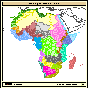
Major hydrological basins and their sub-basins. This dataset divides the African continent according to its hydrological characteristics. The dataset consists of the following information:- numerical code and name of the major basin (MAJ_BAS and MAJ_NAME); - area of the major basin in square km (MAJ_AREA); - numerical code and name of the sub-basin (SUB_BAS and SUB_NAME); - area of the sub-basin in square km (SUB_AREA); - numerical code of the sub-basin towards which the sub-basin flows (TO_SUBBAS) (the codes -888 and -999 have been assigned respectively to internal sub-basins and to sub-basins draining into the sea)
-
Data is in the form of a Microsoft Access databases, excel workbooks and csv files, showing the original data together with site information (GPS coordinates), and date collected. Data is also in the form of a report, which will be a secured (printable, non-editable), searchable, Portable Document Format (PDF) showing the results of the analyses. The aim of the Western Australian Marine Science Institution (WAMSI) DREDGING SCIENCE NODE Project 4.9, is to thoroughly characterise how dredging activities alters reef water quality (i.e. total suspended solids levels (TSS), underwater light levels and photosynthetically active radiation (PAR) i.e. (light attenuation) in terms of temporal and spatial characteristics (including spectral analyses of temporal patterns) and how these changes in water quality impact on coral health. The data are important for developing water quality thresholds for dredging projects and to improve the ability to predict and manage the impact of future projects. Data used to conduct these analyses were from four large scale capital Dredging projects conducted in the Pilbara region of Western Australia using in situ water quality instrumentation, as well as time series photographic images of individual coral heads (available for the Gorgon project at Barrow Island only). Federal Ministerial Approval Statements for the four projects: MS757, MS800, MS840, MS0873, which are searchable on the WA EPA website: http://www.epa.wa.gov.au. These data are available through a data sharing agreement with WAMSI, pending approval of the individual companies.
-
Sea level, currents and winds were measured at several locations on the Great Barrier Reef continental shelf between June and November 1980.Six Aanderaa model RCM4 current meters, recording data at half-hourly intervals, were deployed at Britomart Passage, Brook Island (2 sites), Cape Upstart, Euston Reef, Green Island and Old Reef at depths between 20 and 50m.Seven water level recorders (four Aanderaa model WLR5, two Aanderaa model 3 and one General Oceanic model TG12) recording data at half-hourly intervals using a 56 second integration time, were deployed at Britomart, Carter, Euston, Gilbey, Keeper and Myrmidon Reefs and Coral Creek. Port authorities provided additional sea level and tide data from Gladstone, Townsville and Cairns harbours.Wind and atmospheric pressure data were collected from a Microdata meteorological station installed at Rib Reef (half-hourly). A CSIRO Aanderaa meteorological station provided hourly wind-vector data for Carter Reef. Wind-vector and atmospheric pressure data (3-hourly) for Flinders Reef, Thursday Island, Townsville, Cooktown and Gladstone were obtained from the Commonwealth Bureau of Meteorology.Hydrographic transects from the coast to Myrmidon Reef were carried out monthly. This research was initiated as a component of a study of the physical oceanography of the central region of the Great Barrier Reef. The data collected were used to estimate term balances in the equations for wind-driven shallow-water waves.
-
This data set was collected by one or more temperature loggers deployed around the site of 21-062 Reef.
-
The 'Wireless Sensor Networks Facility' (formerly known as Facility for The Automated Intelligent Monitoring of Marine Systems (FAIMMS)), part of the Great Barrier Reef Ocean Observing System project (GBROOS), is a facility of the Australian 'Integrated Marine Observing System' (IMOS) project. This data set was collected by the Great Barrier Reef Wireless Sensor Network.
-
This data set was collected by weather sensors deployed on the AIMS Weather Station site Myrmidon Reef.
-
This data set was collected by weather sensors deployed on the NERP Weather Station site Badu.
-
The 'Wireless Sensor Networks Facility' (formerly known as Facility for The Automated Intelligent Monitoring of Marine Systems (FAIMMS)), part of the Great Barrier Reef Ocean Observing System project (GBROOS), is a facility of the Australian 'Integrated Marine Observing System' (IMOS) project. This data set was collected by the Great Barrier Reef Wireless Sensor Network.
-
This data set was collected by weather sensors deployed on the NERP Weather Station site Bramble Cay.
-
Towed video surveys between were carried out in targeted shallow seabed environments within and adjacent to the proposed Oceanic Shoals Commonwealth Marine Reserve (CMR) in the Timor Sea. The survey concentrated on shelf habitats (< 200m) of the Oceanic Shoals CMR and included potential biodiversity hotspots such as pinnacles, banks and shoals. In total, 48 towed video transects were collected at depths of between 17.2 and 89 metres. Sampling involved habitat classification, conducted in real-time during the surveys, and taking downward and forward facing photographic still images at 5 second intervals for subsequent analysis. The cameras were towed across the shoals at a speed of 0.5 - 1.5 knots at an altitude of 0.5 - 2 metres above the seabed. The survey was undertaken by the Australian Institute of Marine Science between May 8 and May 16 2014 on the AIMS Research Vessel, RV Solander, and aimed to address strategic knowledge gaps in the Oceanic Shoals bioregion.